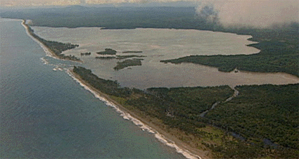
This is an area of low-lying coastal plain broken by isolated hills of basement rocks: Oligocene volcanic arc rocks and associated limestone. Further inland, foothills give way to the steep-fronted Bewani and Torricelli ranges. The coastal plain is bounded seaward by a coastal sand barrier that stands 1-2 m above sea level and is typically a few hundred meters across. The sand barrier is highest at the beachfront and slopes gently downwards away from the sea -- a common morphology for coastlines where sea level is rising relative to the land, and where there is a steady supply of sand distributed along the coast by longshore drift. Much of the sand barrier is planted with coconut palms and there are occasional large trees (kalopilam Callophylum inophyllum; breadfruit or kapiak Atocarpus altissima; talis Terminalia catappa; and mango Magnifera indica) and thickets of yar (Casuarina equisetifolia).
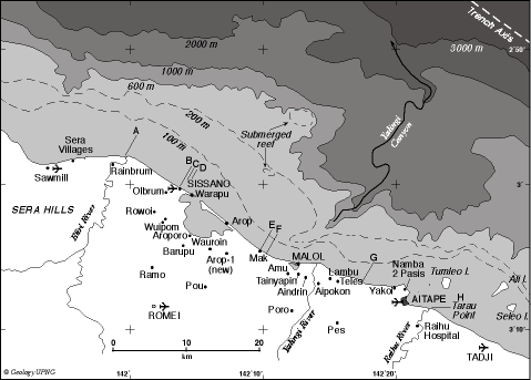
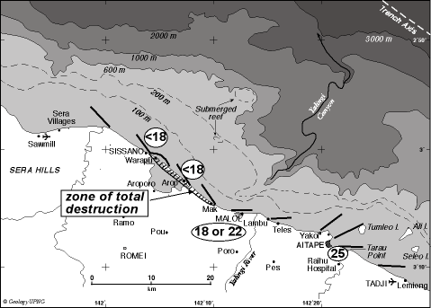
On the evening of 17 July 1998, on the Aitape coast of Papua New Guinea, a strongly felt earthquake was followed some 10-25 minutes later by a destructive tsunami. The tsunami comprised three waves, each estimated to be about 4 m high. The second of the three waves rose to a height of 10-15 m above sea level after it had crossed the shoreline and caused most damage. Maximum wave heights and greatest damage were recorded along a 14-km sector of coast centered on Sissano Lagoon. In this sector the wave fronts moved from east to west along the coast; all structures were destroyed, and 20-40 percent of the population was killed. Partial destruction extended 23 km to the southeast and 8 km to the northwest, and effects of the tsunami were felt as far as 250 km to the west-northwest, beyond the international border. More than 1600 people are known to have died, with some estimates as high as 2200; 1000 were seriously injured, and 10,000 survivors were displaced.
Before the tsunami, about 12,000 people lived in the coastal villages west of Aitape, from Malol to Sissano. Most houses were of traditional materials, and most were within a few hundred meters of the waterfront and on land that was not more than a few metros above sea level. Each village extended for a kilometer or more along the coast.
The main shock was sufficiently vigorous and prolonged that at Malol, Arop and Warapu people left their houses and moved into open space. At Arop and Warapu cracks opened in the ground, and water squirted upwards, house foundation posts shook and water rose around the posts, and there was a smell of hydrogen sulfide. At Sissano Mission the earthquake caused minor damage to the 62-year-old church, and in the nearby villages some houses collapsed. At Malol the shaking was strong enough to cause concern that the water tanks at the Mission might collapse. At Vanimo, 140 km from the epicenter, the earthquake was described by one long term resident as stronger and more prolonged than any he had experienced.
The main shock was followed, some minutes later, by a loud boom, as though of thunder; this was heard from Sissano to Malol. A few minutes or up to five minutes later there was a roaring sound, variously described as the noise of a low-flying heavy jet plane, the approach of a large ship, or as the woop-woop-woop of a heavy helicopter. The sound progressed eastward along the coast then back again to the west, and was heard all along the coast from Sissano in the west to Aitape High School in the east.
Although the sun had set at 6.37 pm, there was still sufficient daylight that the day's activities were continuing. Men were painting a canoe, young people were playing touch football and their elders were moving around in the villages. People went to the beach to investigate the unusual noise and observed that the sea was 'boiling' or bubbling, and had receded by 50 m or so, exposing the nearshore sea bed. They then saw a wave develop in the distance, as a dark line on a sea surface that otherwise reflected the light of the sky. The wave approached and, when 200-300 m from the beach, started to break, rolling from the top. 'Smoke' or haze rose from the top of the wave, and many saw a red glow in the top of the wave.
One observer (John Sanawe, a former Colonel in the PNG Defense Force) reported that he first saw the sea on the skyline rise and explode, sending spray high in the air where it caught and diffracted the late afternoon sunlight into rainbow colors. He then heard a sound like distant thunder. He wondered at hearing thunder on a day when the sky was clear, then linked this sound to the explosion. Then there was a sound like a heavy helicopter, or such as can be heard when a bottle is held under water, and the sea started to retreat from the shore. The rhythm of the helicopter noise slowed as the retreat of the sea slowed. Then there was silence for 4-5 minutes, followed by the noise of a low-flying jet aircraft. Sanawe looked to sea and saw that a wave had formed at or near the site of the explosion. The wave then approached at great speed.
People ran from the approaching waves but almost all were caught. A few escaped by climbing trees, or pushing their boats into the lagoon.
People in the waves were vigorously tumbled and turned in water that was laden with sand and debris. They were stripped of their clothing, lost skin by sand abrasion, were battered by hard objects and some cut or impaled by timber and metal objects. Those who were fortunate were carried into the lagoon and were able to cling to floating debris. An infant was deposited miraculously on the floating roof of a house. Those less fortunate were carried into swampland or into the mangroves that fringe the lagoon where some were impaled or were buried under piles of logs and debris. Some who had survived the initial impact were swept out to sea as the waters receded. Most had ingested water from the waves.
Wave heights, on shore, were 10-15 m above sea level and there was extensive damage for distances of up to 500 m from the coast. Damage was less on either side of a 14-km sector.
 By 7.20 or 7.25 pm the water had retreated, though much standing water remained. At this moment, according to survivors, the sky was filled with a yellow or yellow-red glow that provided sufficient light for people to start searching for family members. They said that without the glow this would not have been possible.
At Sissano Lagoon a low haze had advanced with the wave and this now blotted out the stars, so that it became pitch dark, so dark that people moving inland, away from the lagoon, held on to each other to maintain contact.
Rescue began that night, the survivors helping each other. The first outside help arrived 16 hours after the event on the Saturday morning, and a major rescue effort began a day later, 40 hours after the event.
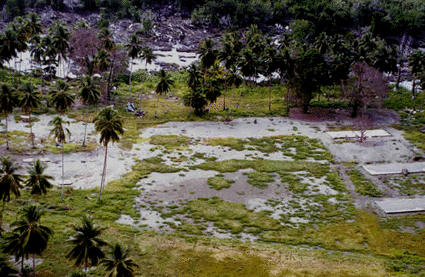 Three concrete slabs (right) are all that remained of the class rooms at Warapu school.
Amazingly, the coconut trees mostly survived.
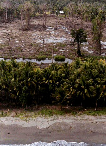 This photo, taken from the sea's edge, at Arop village, shows the destruction inland of the belt of coconut palms at the top of the beach.
And there were other horrors accopanyng the waves, which arrived just after dusk:
John Kimene of Nimas was one of a group that was fishing at a drowned reef 8-10 km from the coast at about 10 am on Thursday 16 July 1998. This probably is the reef marked on the map just inside the 200 m isobath, which stands at 82 m depth. As the party trolled 1-2 km west of the submerged reef they were surprised to run into a succession of 2-3 m waves that loomed and steepened as though about to break. They took this to be evidence of a new shoaling of the water in an area that previously had been quite deep. There was a smell of dead fish.
On Friday 17 July 1998 at about noon Tom Kaisiera, a teenager from Nimas, paddled to the same general area and was surprised to find the sea bubbling with odorless gas. The area of bubbling was large, perhaps 100-200 m across. The canoe was drawn toward the center of bubbling area and it was only by paddling strongly that he could escape.
Three unusual lighting effects were reported. Many observers saw a red light on the horizon before the tsunami developed: "After the first earthquake, a long streak of red light like fire appeared just above the ocean on northern horizon, it flashed and then disappeared, then within seconds there was a loud bang". Also, many observers described a red glow or "fire" in the top of the wave.
After the wave passed, observers at widely separated locations (Warapu, Malol and Raihu) saw a yellow or yellow-red glow in the sky over the sea. "The sky lit up after the wave had destroyed the villages" (observer at Malol) and "after I climbed down from the tree I saw a big light over Arop and in the direction of Aitape" (observer on an island near the lagoon mouth). The Sisters at Malol recall that after the waves had passed they looked seaward and saw a calm golden sea. Warapu survivors recall that the yellow glow in the sky helped light their search for survivors.
I'm indebted to the following excellent report for the pictures and descriptions:
The Aitape 1998 tsunami: Reconstructing the event from interviews and field mapping.